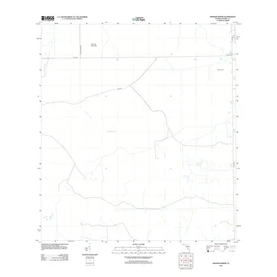
2012 Map of Graham Marsh
USGS Topo · Published 2012About this map
Graham Marsh dominates this landscape in Hendry County, Florida, where the low-lying terrain reveals the intricate drainage and land management patterns of the southern Everglades. The map illustrates a transitional environment where natural features like Tom Still Hammock meet large-scale agricultural and aviation infrastructure. A significant portion of the area is occupied by Devils Garden, a region historically characterized by its wetland mosaic. Evidence of modern development and utility is found at the Alico Airport and a geometric network of access roads, including Collins Slough Rd and Loop Rd. These corridors facilitate movement through the marshy interior, connecting remote tracts to Co Hwy-832 and Co Hwy-833, highlighting the ongoing human efforts to navigate and utilize this seasonally saturated Florida interior.
Find a feature on this map
8 named features on this map. Tap any name to fly to it.
Don’t see what you’re looking for? This feature index may not catch every label — zoom into the map to look around manually.
Map Details
Editions of this 2012 Graham Marsh Map
This is the sole edition of this map. No revisions or reprints were ever made.
Other maps of this area

1956 · West Palm Beach
USGS Topo · 1:250,000

1957 · West Palm Beach
USGS Topo · 1:250,000

1958 · West Palm Beach
USGS Topo · 1:250,000
1958 · Felda SE
USGS Topo · 1:24,000
1958 · Immokalee NE
USGS Topo · 1:24,000
1958 · Felda NE
USGS Topo · 1:24,000
1970 · La Belle 4 SE
USGS Topo · 1:24,000
1970 · La Belle 4 NW
USGS Topo · 1:24,000
1970 · La Belle 4 NE
USGS Topo · 1:24,000
1971 · La Belle 4 SW
USGS Topo · 1:24,000