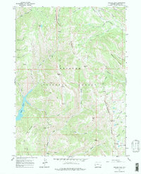
1967 Map of Graham Peak
USGS Topo · Published 1971About this map
Commissary Ridge and Absaroka Ridge dominate this high-elevation terrain within the Bridger National Forest. The landscape is defined by its complex network of seasonal drainages and alpine basins, notably containing Lake Alice and the Fontenelle Lakes. A significant historical corridor is preserved here in the form of the Emigrant Trail (Lander Cutoff), which traverses the northern section of the map near LaBarge Creek. This route represents a vital branch of the Oregon Trail, providing a shorter path for 19th-century travelers through the western mountains. Scattered throughout the peaks like Mount Isabel and Graham Peak are markers of localized human presence, including the high-altitude camp at White Saddle and a remote Drill Hole in the southwest corner, reflecting the intersection of early migration routes and later natural resource exploration.
Find a feature on this map
50 named features on this map. Tap any name to fly to it.
Don’t see what you’re looking for? This feature index may not catch every label — zoom into the map to look around manually.
Map Details
Editions of this 1967 Graham Peak Map
2 editions found
Other maps of this area

1921 · Afton
USGS Topo · 1:125,000

1936 · Cokeville
USGS Topo · 1:96,000

1942 · Cokeville
USGS Topo · 1:125,000

1955 · Preston
USGS Topo · 1:250,000

1958 · Preston
USGS Topo · 1:250,000

1962 · Preston
USGS Topo · 1:250,000

1967 · Devils Hole Creek
USGS Topo · 1:24,000

1967 · Graham Peak
USGS Topo · 1:24,000

1967 · Big Park
USGS Topo · 1:24,000

1967 · Porcupine Creek
USGS Topo · 1:24,000