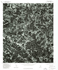
1975 Map of Graham
USGS Topo · Published 1977About this map
Little Tallapoosa River meanders through the heart of this East Alabama and West Georgia borderland, defining a landscape of agricultural clearings and dense timber in the mid-1970s. This orthophotoquad provides a clear visual record of the rural settlement patterns around Graham and the community of Ephesus to the southeast. Unlike traditional line-drawn maps, this aerial perspective captures the exact footprint of farmsteads, winding country lanes, and the varied terrain as it existed when the imagery was captured in late 1975. The settlement of New Mexico sits in the northeast corner of the sheet, illustrating the small, decentralized hubs that characterized this region's rural economy. Researchers can see the precise relationship between the river drainage and the upland fields, offering a unique look at land use before modern development altered these traditional property boundaries.
Find a feature on this map
4 named features on this map. Tap any name to fly to it.
Don’t see what you’re looking for? This feature index may not catch every label — zoom into the map to look around manually.
Map Details
Editions of this 1975 Graham Map
This is the sole edition of this map. No revisions or reprints were ever made.
Other maps of this area

1889 · Tallapoosa
USGS Topo · 1:125,000

1892 · Tallapoosa
USGS Topo · 1:125,000

1897 · Tallapoosa
USGS Topo · 1:125,000

1899 · Wedowee
USGS Topo · 1:125,000

1902 · Wedowee
USGS Topo · 1:125,000

1953 · Atlanta
USGS Topo · 1:250,000

1957 · Atlanta
USGS Topo · 1:250,000

1958 · Atlanta
USGS Topo · 1:250,000

1958 · Carrollton
USGS Topo · 1:62,500

1964 · Roopville
USGS Topo · 1:24,000