
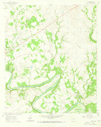
1924 Map of Granbury 1-c
USGS Topo · Published 1924About this map
The Brazos River carves a dramatic series of deep meanders through this portion of Somervell and Hood Counties, creating distinct geographic peninsulas known as Abby Bend, Cordova Bend, Cox Bend, Mitchell Bend, and Turner Bend. This 1924 survey captures a rural landscape defined by these river loops and the early road network connecting small community centers. Local life centers on rural institutions like the Nubbin Ridge Church and several small schoolhouses, including Spunky School and Alta Vista School.
Find a feature on this map
25 named features on this map. Tap any name to fly to it.
Don’t see what you’re looking for? This feature index may not catch every label — zoom into the map to look around manually.
Map Details
Editions of this 1924 Granbury 1-c Map
This is the sole edition of this map. No revisions or reprints were ever made.
Other maps of this area

1889 · Granbury
USGS Topo · 1:125,000

1923 · Granbury 2-a
USGS Topo · 1:48,000

1923 · Granbury 1-b
USGS Topo · 1:48,000

1924 · Granbury 4-a
USGS Topo · 1:48,000

1928 · Godley
USGS Topo · 1:62,500

1931 · Morgan
USGS Topo · 1:62,500

1931 · Tolar
USGS Topo · 1:62,500

1954 · Dallas
USGS Topo · 1:250,000

1958 · Dallas
USGS Topo · 1:250,000
1961 · Acton
USGS Topo · 1:24,000