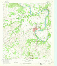
1961 Map of Granbury
USGS Topo · Published 1970About this map
Granbury and its surrounding river loops define the central landscape of this 1960s study, showcasing the town just as its modern footprint was emerging. The Brazos River meanders sharply through the quadrangle, creating distinctive landforms like Stockton Bend and Peveler Valley. To the south, the prominent elevation of Comanche Peak stands as a clear landmark above the rolling terrain.
Find a feature on this map
40 named features on this map. Tap any name to fly to it.
Don’t see what you’re looking for? This feature index may not catch every label — zoom into the map to look around manually.
Map Details
Editions of this 1961 Granbury Map
Other maps of this area

1889 · Granbury
USGS Topo · 1:125,000

1891 · Weatherford
USGS Topo · 1:125,000

1893 · Weatherford
USGS Topo · 1:125,000

1923 · Granbury 2-a
USGS Topo · 1:48,000

1923 · Granbury 1-b
USGS Topo · 1:48,000

1924 · Weatherford 3-d
USGS Topo · 1:48,000

1924 · Granbury 1-c
USGS Topo · 1:48,000

1928 · Godley
USGS Topo · 1:62,500

1931 · Dennis
USGS Topo · 1:62,500

1931 · Tolar
USGS Topo · 1:62,500