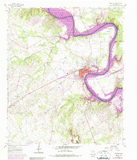
1961 Map of Granbury
USGS Topo · Published 1987About this map
Brazos River loops through Hood County in this topographical survey, showcasing the dramatic winding course of the waterway as it becomes Lake Granbury. The county seat of Granbury is detailed with its street grid, including Pearl St and Doyle St, while the town's early growth is marked by its proximity to the Atchison Topeka and Santa Fe railroad line. Local history and genealogy are anchored by several notable burial grounds, such as Thorp Spring Cem and Friendship Cem. To the south, the prominent elevation of Comanche Peak rises above the surrounding terrain of Rough Creek and Fall Branch. This map documents a period of significant hydraulic change, with purple revisions highlighting the extent of the reservoir as it reshaped the river valley near Stockton Bend and Eden.
Find a feature on this map
37 named features on this map. Tap any name to fly to it.
Don’t see what you’re looking for? This feature index may not catch every label — zoom into the map to look around manually.
Map Details
Editions of this 1961 Granbury Map
Other maps of this area

1889 · Granbury
USGS Topo · 1:125,000

1891 · Weatherford
USGS Topo · 1:125,000

1893 · Weatherford
USGS Topo · 1:125,000

1923 · Granbury 2-a
USGS Topo · 1:48,000

1923 · Granbury 1-b
USGS Topo · 1:48,000

1924 · Weatherford 3-d
USGS Topo · 1:48,000

1924 · Granbury 1-c
USGS Topo · 1:48,000

1928 · Godley
USGS Topo · 1:62,500

1931 · Dennis
USGS Topo · 1:62,500

1931 · Tolar
USGS Topo · 1:62,500