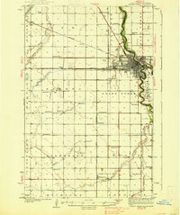
1938 Map of Grand Forks
USGS Topo · Published 1938About this map
The Red River of the North anchors this 1930s landscape, serving as the meandering boundary between North Dakota and Minnesota. Centered on Grand Forks, the map details a region defined by its academic and agricultural foundations during the Great Depression. The campus of the University of North Dakota and nearby Wesley College appear on the city's edge, adjacent to the local Landing Field.
Find a feature on this map
55 named features on this map. Tap any name to fly to it.
Don’t see what you’re looking for? This feature index may not catch every label — zoom into the map to look around manually.
Map Details
Editions of this 1938 Grand Forks Map
3 editions found
Other maps of this area

1918 · Warren
USGS Topo · 1:62,500

1919 · Eldred
USGS Topo · 1:62,500

1926 · Ardoch
USGS Topo · 1:62,500

1934 · Emerado
USGS Topo · 1:48,000

1934 · Grand Forks
USGS Topo · 1:24,000

1934 · Grand Forks
USGS Topo · 1:62,500

1936 · Emerado
USGS Topo · 1:62,500

1938 · Grand Forks
USGS Topo · 1:62,500

1952 · Grand Forks
USGS Topo · 1:250,000

1952 · Thief River Falls
USGS Topo · 1:250,000