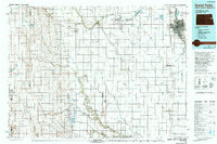
1985 Map of Grand Forks
USGS Topo · Published 1990About this map
The Red River of the North defines the eastern edge of this Red River Valley survey, separating Grand Forks from East Grand Forks in a region characterized by its expansive agricultural grid and military presence. This mid-1980s landscape is dominated by the strategic footprint of the Grand Forks Air Force Base and the Grand Forks International Airport, while the Burlington Northern Railroad and Interstate 29 facilitate the transport of goods through the valley.
Find a feature on this map
106 named features on this map. Tap any name to fly to it.
Don’t see what you’re looking for? This feature index may not catch every label — zoom into the map to look around manually.
Map Details
Editions of this 1985 Grand Forks Map
2 editions found
Other maps of this area

1918 · Kelso
USGS Topo · 1:62,500

1918 · Hendrum
USGS Topo · 1:62,500

1918 · Warren
USGS Topo · 1:62,500

1919 · Eldred
USGS Topo · 1:62,500

1926 · Ardoch
USGS Topo · 1:62,500

1934 · Emerado
USGS Topo · 1:48,000

1934 · Grand Forks
USGS Topo · 1:24,000

1934 · Grand Forks
USGS Topo · 1:62,500

1936 · Emerado
USGS Topo · 1:62,500

1936 · Larimore
USGS Topo · 1:62,500