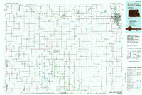
1985 Map of Grand Forks
USGS Topo · Published 1985About this map
The Red River of the North serves as the vital boundary between Grand Forks and East Grand Forks, anchoring a landscape shaped by the agricultural and aviation interests of the mid-1980s. The sprawling Grand Forks Air Force Base and the Grand Forks International Airport highlight the region's importance as a strategic and logistical hub. Beyond the urban centers, the prairie is punctuated by small rail towns like Larimore, Northwood, and Mayville, many situated along the Burlington Northern lines that facilitate the movement of grain. Conservation and recreation are central to the terrain, from the riparian corridors of Turtle River State Park to the waterfowl habitats of Little Goose National Wildlife Refuge and Kellys Slough. This survey captures the intersection of established homesteads and modern defense infrastructure during a period of steady growth in the Red River Valley.
Find a feature on this map
66 named features on this map. Tap any name to fly to it.
Don’t see what you’re looking for? This feature index may not catch every label — zoom into the map to look around manually.
Map Details
Editions of this 1985 Grand Forks Map
2 editions found
Other maps of this area

1918 · Kelso
USGS Topo · 1:62,500

1918 · Hendrum
USGS Topo · 1:62,500

1918 · Warren
USGS Topo · 1:62,500

1919 · Eldred
USGS Topo · 1:62,500

1926 · Ardoch
USGS Topo · 1:62,500

1934 · Emerado
USGS Topo · 1:48,000

1934 · Grand Forks
USGS Topo · 1:24,000

1934 · Grand Forks
USGS Topo · 1:62,500

1936 · Emerado
USGS Topo · 1:62,500

1936 · Larimore
USGS Topo · 1:62,500