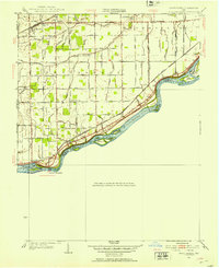
1952 Map of Grand Rapids
USGS Topo · Published 1953About this map
The Maumee River corridor defines this mid-century landscape, carving a wide path through Lucas and Wood Counties. Along its banks, the Providence Dam and Providence Park mark the historic settlement patterns of the river valley, while a string of islands—including Missionary Island, Indian Island, and Millers Island—dot the channel. The map records the transition of land use from the riverbank to the interior, where the Wabash RR serves the northern settlement of Neapolis.
Find a feature on this map
69 named features on this map. Tap any name to fly to it.
Don’t see what you’re looking for? This feature index may not catch every label — zoom into the map to look around manually.
Map Details
Editions of this 1952 Grand Rapids Map
This is the sole edition of this map. No revisions or reprints were ever made.
Other maps of this area

1900 · Toledo
USGS Topo · 1:62,500

1901 · Bowling Green
USGS Topo · 1:62,500

1903 · Bowling Green
USGS Topo · 1:62,500

1909 · Mc Clure
USGS Topo · 1:62,500

1911 · Swanton
USGS Topo · 1:62,500

1914 · Swanton
USGS Topo · 1:62,500

1935 · Grand Rapids
USGS Topo · 1:24,000

1935 · Whitehouse
USGS Topo · 1:24,000

1935 · Maumee
USGS Topo · 1:24,000
1938 · Maumee
USGS Topo · 1:31,680