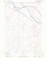
1947 Map of Grand View
USGS Topo · Published 1978About this map
Grand View serves as the focal point of this 1947 study, situated on the banks of the Snake River where the boundary between Elmore and Owyhee counties follows the river's course. The landscape is defined by its extensive water management infrastructure, including the Grand View Mutual Irrigation District Canal, Low Line Canal, and Middle Line Canal, which transformed the arid Twenty Mile Flat for agricultural use. Local family-named sites such as Dixie Ranch, Shoofly Ranch, and Whitson Ranch reflect the settlement patterns of the mid-20th century. Notable landmarks like the Hot Well, Landing Strip, and several artesian wells indicate both natural resources and the development of local transport and utility networks. The presence of tailings near Gold Isle suggests historical mining activity, while the local cemetery provides a critical point of interest for genealogical research in this river valley community.
Find a feature on this map
22 named features on this map. Tap any name to fly to it.
Don’t see what you’re looking for? This feature index may not catch every label — zoom into the map to look around manually.
Map Details
Editions of this 1947 Grand View Map
3 editions found
Other maps of this area

1892 · Mountain Home
USGS Topo · 1:125,000

1892 · Bisuka
USGS Topo · 1:125,000

1893 · Mountain Home
USGS Topo · 1:125,000

1894 · Bisuka
USGS Topo · 1:125,000

1946 · Mouth of Bruneau
USGS Topo · 1:24,000

1947 · Little Valley
USGS Topo · 1:24,000

1947 · Grand View
USGS Topo · 1:62,500

1947 · Bruneau
USGS Topo · 1:62,500

1947 · Grand View
USGS Topo · 1:24,000

1947 · Jackass Butte
USGS Topo · 1:24,000