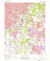
1964 Map of Grandview
USGS Topo · Published 1976About this map
The Kansas Missouri state line bisects this mid-century landscape, capturing the rapid suburbanization of south Kansas City and its neighbors. To the east, Jackson County, Missouri, transitions from the industrial corridor of the Blue River to established residential communities like Waldo and Marlborough. The map documents a significant network of transportation, including the Kansas City Southern and Missouri Pacific railroads, which parallel the river valley. Numerous educational and religious institutions are plotted, from St James Seminary to Avila College, alongside extensive memorial grounds such as Mt Moriah Cemetery.
Find a feature on this map
102 named features on this map. Tap any name to fly to it.
Don’t see what you’re looking for? This feature index may not catch every label — zoom into the map to look around manually.
Map Details
Editions of this 1964 Grandview Map
4 editions found
Other maps of this area

1887 · Harrisonville
USGS Topo · 1:125,000

1887 · Olathe
USGS Topo · 1:125,000

1890 · Kansas City
USGS Topo · 1:125,000

1892 · Harrisonville
USGS Topo · 1:125,000

1893 · Olathe
USGS Topo · 1:125,000

1894 · Kansas City
USGS Topo · 1:125,000

1894 · Harrisonville
USGS Topo · 1:125,000

1894 · Independence
USGS Topo · 1:125,000

1934 · Independence
USGS Topo · 1:24,000

1934 · Grandview
USGS Topo · 1:24,000