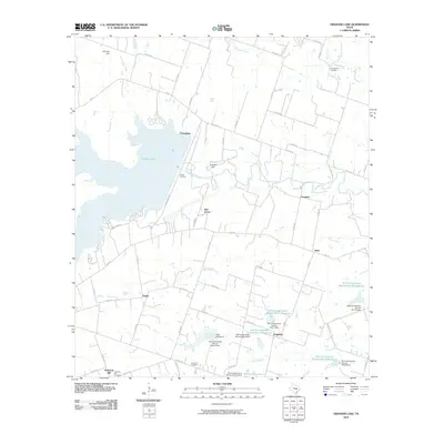
2010 Map of Granger Lake
USGS Topo · Published 2010About this map
Granger Lake and the Granger Dam dominate this Central Texas landscape, where the waters of the San Gabriel River are harnessed for flood control and conservation. The surrounding terrain is a network of small agricultural settlements and rural road systems, including Friendship, Laneport, and Hare. This era is defined by extensive water management efforts, evidenced by the numerous Soil Conservation Service sites, such as the Soil Conservation Service Site 7 Reservoir and several numbered dams along Pecan Creek and Turkey Creek. Genealogy interests are well-served by the presence of family-named landmarks and resting places like the C A Hamblen Cemetery, Young Cemetery, and the Wuthrich Hill Cemetery near Wuthrich Hill. Small communities like Hoxie, Sandoval, and New Bern provide a look at the persistent rural layout of Williamson County in the early 21st century.
Find a feature on this map
66 named features on this map. Tap any name to fly to it.
Don’t see what you’re looking for? This feature index may not catch every label — zoom into the map to look around manually.
Map Details
Editions of this 2010 Granger Lake Map
This is the sole edition of this map. No revisions or reprints were ever made.
Other maps of this area

1885 · Taylor
USGS Topo · 1:125,000

1887 · Taylor
USGS Topo · 1:125,000

1894 · Taylor
USGS Topo · 1:125,000

1910 · Buckholts
USGS Topo · 1:24,000

1912 · Buckholts
USGS Topo · 1:31,680

1954 · Austin
USGS Topo · 1:250,000
1963 · Sharp
USGS Topo · 1:24,000

1963 · Friendship
USGS Topo · 1:24,000
1963 · San Gabriel
USGS Topo · 1:24,000
1963 · Davilla
USGS Topo · 1:24,000