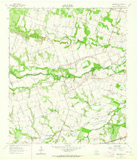
1963 Map of San Gabriel
USGS Topo · Published 1964About this map
The San Gabriel River meanders across the center of this rural landscape, defining the character of the border between Williamson and Milam counties in the early 1960s. The small settlement of San Gabriel sits just north of the river, while a distinct network of local landmarks such as the Cotton Gin and a Landing Strip reflect the agricultural and early aviation infrastructure of the period. The area is dotted with family and community legacy sites, including the Hamilton Cem and the Springfield Ch near Liberty Hill.
Find a feature on this map
27 named features on this map. Tap any name to fly to it.
Don’t see what you’re looking for? This feature index may not catch every label — zoom into the map to look around manually.
Map Details
Editions of this 1963 San Gabriel Map
2 editions found
Other maps of this area

1885 · Taylor
USGS Topo · 1:125,000

1887 · Taylor
USGS Topo · 1:125,000

1894 · Taylor
USGS Topo · 1:125,000

1910 · Buckholts
USGS Topo · 1:24,000

1912 · Buckholts
USGS Topo · 1:31,680

1954 · Austin
USGS Topo · 1:250,000

1962 · Rockdale West
USGS Topo · 1:24,000
1962 · Pettibone
USGS Topo · 1:24,000
1963 · Sharp
USGS Topo · 1:24,000

1963 · Friendship
USGS Topo · 1:24,000