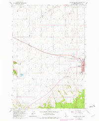
1963 Map of Grangeville West
USGS Topo · Published 1982About this map
Camas Prairie dominates the landscape of this 1963 Idaho survey, showcasing a region defined by its wide agricultural expanses and high plateau geography. The town of Grangeville serves as the primary hub, with its urban footprint detailed alongside the High Sch, a Radio Tower, and the County Airport. To the northwest, the smaller settlement of Denver sits near the headwaters of South Fork Cottonwood Creek.
Find a feature on this map
19 named features on this map. Tap any name to fly to it.
Don’t see what you’re looking for? This feature index may not catch every label — zoom into the map to look around manually.
Map Details
Editions of this 1963 Grangeville West Map
2 editions found
Other maps of this area

1924 · Kamiah
USGS Topo · 1:125,000

1955 · Pullman
USGS Topo · 1:250,000

1955 · Grangeville
USGS Topo · 1:250,000

1958 · Pullman
USGS Topo · 1:250,000

1959 · Grangeville
USGS Topo · 1:250,000

1963 · Goodwin Meadows
USGS Topo · 1:24,000

1963 · Grangeville West
USGS Topo · 1:24,000

1963 · White Bird Hill
USGS Topo · 1:24,000
1963 · Grangeville East
USGS Topo · 1:24,000

1963 · White Bird
USGS Topo · 1:24,000