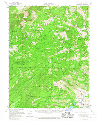
1953 Map of Granite Chief
USGS Topo · Published 1966About this map
The Royal Gorge of the North Fork American River dominates this mid-century survey of the High Sierra, where the Tahoe National Forest meets rugged industrial activity. Mining history is deeply etched into the terrain, evidenced by several specialized sites including the Walker Mine, Trinidad Mine, and the X Ray Mine. The map highlights a complex network of trails and jeep tracks connecting isolated landmarks like the Johnson Monument and various seasonal camps. High-altitude hydrology is a central theme, from the drainage of Wabena Creek to the expansive Loon Lake and the Mud Lakes group in the south. High peaks such as Granite Chief and Tinker Knob overlook a landscape of canyons and meadows used for both resource extraction and early mountain recreation at sites like Robinsons Flat and the French Meadows Guard Sta.
Find a feature on this map
143 named features on this map. Tap any name to fly to it.
Don’t see what you’re looking for? This feature index may not catch every label — zoom into the map to look around manually.
Map Details
Editions of this 1953 Granite Chief Map
5 editions found

Other maps of this area

1889 · Pyramid Peak
USGS Topo · 1:125,000

1891 · Colfax
USGS Topo · 1:125,000

1891 · Truckee
USGS Topo · 1:125,000

1891 · Placerville
USGS Topo · 1:125,000

1891 · Pyramid Peak
USGS Topo · 1:125,000

1892 · Placerville
USGS Topo · 1:125,000

1892 · Colfax
USGS Topo · 1:125,000

1893 · Placerville
USGS Topo · 1:125,000

1893 · Truckee
USGS Topo · 1:125,000

1894 · Colfax
USGS Topo · 1:125,000