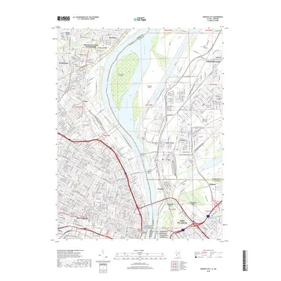
2018 Map of Granite City
USGS Topo · Published 2018About this map
The Mississippi River and the industrial infrastructure of the American Bottoms dominate this landscape, illustrating the complex relationship between the urban centers of St. Louis and Granite City during the early 21st century. The map reveals a dense network of transit and heritage sites, including the massive Calvary and Bellefontaine cemeteries that overlook the river from the Missouri side. On the Illinois bank, the Chain of Rocks Canal and Gabaret Slough bypass the main channel, facilitating heavy river traffic past the islands of Mosenthein Island and Kerr Island. Important river crossings like the McKinley Bridge, Merchants Bridge, and Eads Bridge link the two states, while the Jefferson National Expansion Memorial stands at the heart of the riverfront. The map also detail academic and residential pockets, from Ranken Technical College to the historic streets of Venice and Brooklyn.
Find a feature on this map
66 named features on this map. Tap any name to fly to it.
Don’t see what you’re looking for? This feature index may not catch every label — zoom into the map to look around manually.
Map Details
Editions of this 2018 Granite City Map
This is the sole edition of this map. No revisions or reprints were ever made.
Other maps of this area

1888 · St. Louis
USGS Topo · 1:62,500

1927 · Alton
USGS Topo · 1:62,500

1927 · St. Charles
USGS Topo · 1:62,500

1931 · French Village
USGS Topo · 1:24,000

1933 · Granite City
USGS Topo · 1:24,000

1933 · Jefferson Barracks
USGS Topo · 1:24,000

1933 · Cahokia
USGS Topo · 1:24,000

1933 · Clayton
USGS Topo · 1:24,000

1933 · Saint Charles
USGS Topo · 1:62,500

1934 · Cahokia
USGS Topo · 1:24,000