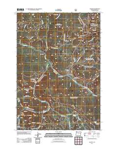
2011 Map of Granite
USGS Topo · Published 2011About this map
Granite and the nearby settlement of Alamo serve as the focal points for a landscape defined by an intensive history of hard-rock and placer mining. This survey documents a complex network of claims and workings concentrated along the drainage of Granite Creek and its many tributaries, including Bull Run Creek and Olive Creek. Notable industrial landmarks like the Buffalo Mine, Red Boy Mine, and Cougar Mine are joined by subterranean features such as the Boston Tunnel and Cox Tunnels.
Find a feature on this map
76 named features on this map. Tap any name to fly to it.
Don’t see what you’re looking for? This feature index may not catch every label — zoom into the map to look around manually.
Map Details
Editions of this 2011 Granite Map
This is the sole edition of this map. No revisions or reprints were ever made.
Other maps of this area

1901 · Sumpter
USGS Topo · 1:125,000

1951 · Bates
USGS Topo · 1:62,500

1951 · Desolation Butte
USGS Topo · 1:62,500

1955 · Canyon City
USGS Topo · 1:250,000

1959 · Canyon City
USGS Topo · 1:250,000

1961 · Whitney
USGS Topo · 1:24,000

1972 · Trout Meadows
USGS Topo · 1:24,000

1972 · Mt. Ireland
USGS Topo · 1:24,000
1972 · Granite
USGS Topo · 1:24,000

1972 · Greenhorn
USGS Topo · 1:24,000