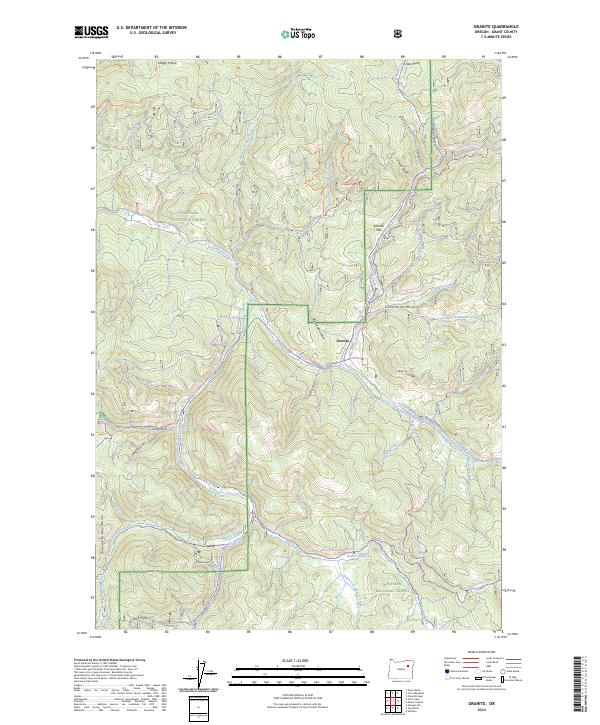
2024 Map of Granite
USGS Topo · Published 2024About this map
Granite sits at the heart of this landscape, positioned where Granite Creek meets Lamb Creek in the high country of Eastern Oregon. The settlement pattern reflects the area's deep ties to the Elkhorn Mountains and Greenhorn Mountains, with surrounding features like Sawmill Flat and Quebec Hill suggesting the resource-driven history of the region. The map documents an extensive network of modern trails and forest routes, including the Elkhorn Drive Snowmobile Trl and Ukiah-Granite Road 52, which now traverse terrain once defined by earlier mining and timber activity. National forest boundaries create a mosaic of management across the territory, with the North Fork John Day Wilderness and Whitman National Forest preserving the character of the drainages. Numerous gulches such as Congo Gulch and Mosquito Gulch feed into the primary creek systems, illustrating the complex hydrology that historically drew prospectors to these high-elevation valleys.
Find a feature on this map
55 named features on this map. Tap any name to fly to it.
Don’t see what you’re looking for? This feature index may not catch every label — zoom into the map to look around manually.
Map Details
Editions of this 2024 Granite Map
This is the sole edition of this map. No revisions or reprints were ever made.
Other maps of this area

1901 · Sumpter
USGS Topo · 1:125,000

1951 · Bates
USGS Topo · 1:62,500

1951 · Desolation Butte
USGS Topo · 1:62,500

1955 · Canyon City
USGS Topo · 1:250,000

1959 · Canyon City
USGS Topo · 1:250,000

1961 · Whitney
USGS Topo · 1:24,000

1972 · Trout Meadows
USGS Topo · 1:24,000

1972 · Mt. Ireland
USGS Topo · 1:24,000
1972 · Granite
USGS Topo · 1:24,000

1972 · Greenhorn
USGS Topo · 1:24,000