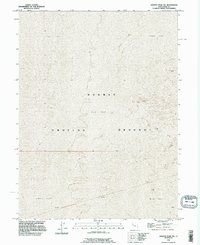
1993 Map of Granite Peak NW
USGS Topo · Published 1996About this map
Dugway Proving Ground dominates this 1990s landscape in Tooele County, representing a significant military installation in the Utah desert. The terrain is characterized by an expansive Mud Flat, showing the subtle topography and surveyors' control points used to monitor this restricted area. Topographic contours with five-foot intervals reveal the nearly level desert floor, where slight elevation changes are critical for understanding the hydrology and drainage patterns of the region. This survey, revised in 1993, documents the remote character of the proving ground before the turn of the twenty-first century, providing a clear record of the range boundaries and township lines including R 15 W and R 14 W.
Find a feature on this map
4 named features on this map. Tap any name to fly to it.
Don’t see what you’re looking for? This feature index may not catch every label — zoom into the map to look around manually.
Map Details
Editions of this 1993 Granite Peak NW Map
This is the sole edition of this map. No revisions or reprints were ever made.
Other maps of this area

1953 · Tooele
USGS Topo · 1:250,000

1954 · Granite Peak
USGS Topo · 1:24,000

1954 · Wildcat Mtn SE
USGS Topo · 1:24,000

1954 · Granite Peak SE
USGS Topo · 1:24,000

1955 · Tooele
USGS Topo · 1:250,000
1973 · Gold Hill 4 SE
USGS Topo · 1:24,000

1973 · Wildcat Mountain SW
USGS Topo · 1:24,000

1973 · Gold Hill 1 SE
USGS Topo · 1:24,000

1973 · Granite Peak NW
USGS Topo · 1:24,000
1973 · Granite Peak SW
USGS Topo · 1:24,000