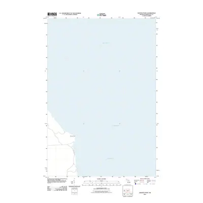
2011 Map of Granite Point
USGS Topo · Published 2011About this map
Lake Superior dominates the landscape of this 2011 survey along the Michigan shoreline in Marquette County. The prominent shoreline feature, Granite Point, projects into the water, serving as a landmark along the coastal stretch of Powell Township. Inland access is provided via County Hwy KB, which runs roughly parallel to the lakefront, connecting the localized terrain to the broader regional road network. This map reflects the quiet, shoreline-focused character of the area, where the vast water body meets the wooded coastal reaches of the Upper Peninsula.
Find a feature on this map
3 named features on this map. Tap any name to fly to it.
Don’t see what you’re looking for? This feature index may not catch every label — zoom into the map to look around manually.
Map Details
Editions of this 2011 Granite Point Map
This is the sole edition of this map. No revisions or reprints were ever made.
Other maps of this area

1907 · Marquette
USGS Topo · 1:62,500

1953 · Marquette NW
USGS Topo · 1:24,000

1954 · Negaunee
USGS Topo · 1:62,500

1954 · Big Bay
USGS Topo · 1:62,500

1954 · Marquette
USGS Topo · 1:62,500

1958 · Marquette
USGS Topo · 1:250,000

1960 · Marquette
USGS Topo · 1:250,000

1961 · Marquette
USGS Topo · 1:250,000

1968 · Marquette
USGS Topo · 1:250,000
1985 · Granite Point
USGS Topo · 1:24,000