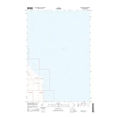
2014 Map of Granite Point
USGS Topo · Published 2014About this map
Lake Superior dominates the landscape of this northern Michigan quadrangle, where the cold waters meet the rocky coastline of the Upper Peninsula. The shoreline is punctuated by Granite Point, a prominent natural landmark that serves as a focal point for the surrounding terrain. Inland, the map details the transition from the lake's edge to the wooded areas of Marquette County, navigated primarily by local routes such as Co Road KCB and Granite Point Rd. This 2014 survey illustrates the sparse development and preservation of the coastal environment, showing how the Public Land Survey System divisions, including t51n r26w and t50n r26w, structure the land ownership and management near the Great Lakes shore.
Find a feature on this map
7 named features on this map. Tap any name to fly to it.
Don’t see what you’re looking for? This feature index may not catch every label — zoom into the map to look around manually.
Map Details
Editions of this 2014 Granite Point Map
This is the sole edition of this map. No revisions or reprints were ever made.
Other maps of this area

1907 · Marquette
USGS Topo · 1:62,500

1953 · Marquette NW
USGS Topo · 1:24,000

1954 · Negaunee
USGS Topo · 1:62,500

1954 · Big Bay
USGS Topo · 1:62,500

1954 · Marquette
USGS Topo · 1:62,500

1958 · Marquette
USGS Topo · 1:250,000

1960 · Marquette
USGS Topo · 1:250,000

1961 · Marquette
USGS Topo · 1:250,000

1968 · Marquette
USGS Topo · 1:250,000
1985 · Granite Point
USGS Topo · 1:24,000