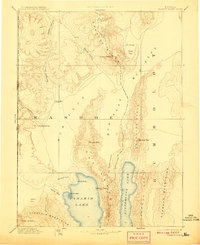
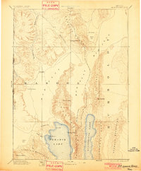
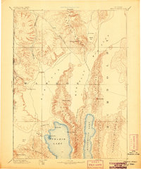
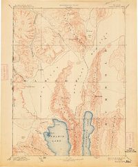
1894 Map of Granite Range
USGS Topo · Published 1908About this map
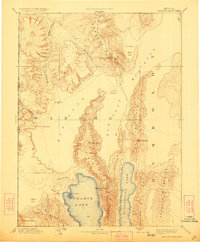
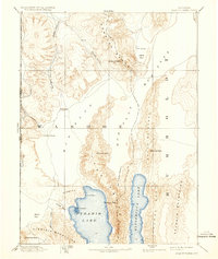
Pyramid Lake and its neighboring Winnemucca Lake anchor this reconnaissance of the Great Basin during the late 19th century. The mapping, compiled from the earlier Wheeler and King surveys, highlights the arid transition between the high mountain ranges and the sprawling alkaline basins. A distinct Salt Works near the center of the sheet indicates the early industrial utilization of the Mud Flat regions. The landscape is defined by its massive vertical relief, stretching from the water's edge at The Needles to the summit of Granite Peak. Transportation routes are sparse, though Astor Pass provides a navigable corridor through the volcanic terrain of the Virginia Mountains. Scattered water sources like Sheep-head Spring and Hot Springs were critical markers for travelers and surveyors navigating the Washoe region and the Nevada California Boundary Line.
Find a feature on this map
33 named features on this map. Tap any name to fly to it.
Don’t see what you’re looking for? This feature index may not catch every label — zoom into the map to look around manually.
Map Details
Editions of this 1894 Granite Range Map
7 editions found

Other maps of this area

1886 · Alturas
USGS Topo · 1:250,000

1886 · Honey Lake
USGS Topo · 1:250,000

1886 · Disaster
USGS Topo · 1:250,000

1886 · Granite Range
USGS Topo · 1:250,000

1889 · Long Valley
USGS Topo · 1:250,000

1890 · Wadsworth
USGS Topo · 1:125,000

1890 · Sierraville
USGS Topo · 1:125,000

1891 · Honey Lake
USGS Topo · 1:250,000

1891 · Reno
USGS Topo · 1:125,000

1892 · Wadsworth
USGS Topo · 1:125,000