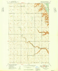
1949 Map of Grano SW
USGS Topo · Published 1949About this map
The Upper Souris National Wildlife Refuge dominates the northeastern corner of this North Dakota landscape, centered on the waters of Lake Darling and its controlled Spillway. Established as part of the Missouri River Basin development program, this survey illustrates a transition from the elevated White Ash Plain to the winding drainage of Mackobee Coulee. The rural social fabric of Renville County is mapped through scattered landmarks such as Gethsemane Ch, School No 1, and School No 2, alongside township divisions like Ivanhoe and Callahan. The terrain is characterized by numerous small depressions and potholes typical of this prairie region, reflecting the local hydrology before mid-century agricultural intensification altered many such features.
Find a feature on this map
13 named features on this map. Tap any name to fly to it.
Don’t see what you’re looking for? This feature index may not catch every label — zoom into the map to look around manually.
Map Details
Editions of this 1949 Grano SW Map
2 editions found
Other maps of this area

1947 · Tolley
USGS Topo · 1:62,500

1948 · Tolley
USGS Topo · 1:24,000

1949 · Tolley SE
USGS Topo · 1:24,000

1949 · Hartland
USGS Topo · 1:24,000

1949 · Carpio NE
USGS Topo · 1:24,000

1949 · Carpio
USGS Topo · 1:24,000

1949 · Grano SW
USGS Topo · 1:24,000

1949 · Greene
USGS Topo · 1:24,000

1949 · Grano
USGS Topo · 1:24,000

1949 · Grano NE
USGS Topo · 1:24,000