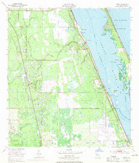
1949 Map of Grant
USGS Topo · Published 1971About this map
The Valkaria Missile Tracking Annex stands as a focal point of this mid-century landscape, reflecting the region's mid-20th-century transition toward aerospace and defense operations. Situated between the Indian River and the mainland swamps, the Valkaria Airfield and its associated military grounds dominate the central terrain. Along the shoreline, the Florida East Coast railway serves the established waterfront communities of Malabar, Valkaria, and Grant, which are oriented toward the sheltered waters of the Intracoastal Waterway. The map captures the specialized geography of the Space Coast, where the historic land divisions of the Fleming Grant meet modern aviation and telemetry infrastructure. Extensive marshes and small creeks like Goat Creek and Kid Creek define the interior, while the barrier islands across the river separate the lagoon from the Atlantic Ocean.
Find a feature on this map
34 named features on this map. Tap any name to fly to it.
Don’t see what you’re looking for? This feature index may not catch every label — zoom into the map to look around manually.
Map Details
Editions of this 1949 Grant Map
4 editions found
Other maps of this area

1949 · Melbourne West
USGS Topo · 1:24,000

1949 · Fellsmere
USGS Topo · 1:24,000

1949 · Melbourne East
USGS Topo · 1:24,000

1949 · Sebastian NW
USGS Topo · 1:24,000

1949 · Sebastian
USGS Topo · 1:24,000

1949 · Grant
USGS Topo · 1:24,000

1951 · Sebastian NW
USGS Topo · 1:24,000

1951 · Melbourne East
USGS Topo · 1:24,000

1951 · Fellsmere
USGS Topo · 1:24,000

1951 · Melbourne West
USGS Topo · 1:24,000