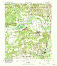
1948 Map of Grant
USGS Topo · Published 1973About this map
The Red River corridor defines the boundary between Oklahoma and Texas on this mid-century survey, where the winding channel creates complex land features like Pitts Bend and Allen Island. North of the river, Choctaw County is characterized by a dense network of local schools and cemeteries serving rural communities such as Goodland and Grant. Significant cultural landmarks like the Goodland School and Goodland Cem appear alongside the St Louis San Francisco railroad line, which provides a primary transport spine through the region.
Find a feature on this map
70 named features on this map. Tap any name to fly to it.
Don’t see what you’re looking for? This feature index may not catch every label — zoom into the map to look around manually.
Map Details
Editions of this 1948 Grant Map
2 editions found
Other maps of this area

1901 · Antlers
USGS Topo · 1:125,000

1901 · Alikchi
USGS Topo · 1:125,000

1903 · Paris
USGS Topo · 1:125,000

1912 · Antlers
USGS Topo · 1:125,000

1925 · Antlers
USGS Topo · 1:125,000

1947 · Honey Grove
USGS Topo · 1:62,500

1948 · Grant
USGS Topo · 1:62,500

1948 · Paris
USGS Topo · 1:62,500

1948 · Direct
USGS Topo · 1:62,500

1949 · Direct
USGS Topo · 1:62,500