
1949 Map of Grant
USGS Topo · Published 1949About this map
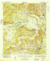
The Red River creates a meandering border between Oklahoma and Texas, defining the geographic center of this late 1940s landscape. North of the river, the Muddy Boggy River joins the main channel near Hills Chapel School, while the St Louis San Francisco railroad provides a vertical transportation corridor through Grant and across the river into Arthur City. This era shows a transition in land use, as traditional rural settlements like Chicota and Goodland coexist with the massive Camp Maxey Military Reservation spanning the southern portion of the sheet. For genealogists and local historians, the map is remarkably detailed in its documentation of community life, noting numerous country schools such as Davis Sch and Post Oak Sch, alongside local landmarks like Forest Chapel and the Goodland Cem.
Find a feature on this map
73 named features on this map. Tap any name to fly to it.
Don’t see what you’re looking for? This feature index may not catch every label — zoom into the map to look around manually.
Map Details
Editions of this 1949 Grant Map
2 editions found
Other maps of this area

1901 · Antlers
USGS Topo · 1:125,000

1901 · Alikchi
USGS Topo · 1:125,000

1903 · Paris
USGS Topo · 1:125,000

1912 · Antlers
USGS Topo · 1:125,000

1925 · Antlers
USGS Topo · 1:125,000

1947 · Honey Grove
USGS Topo · 1:62,500

1948 · Grant
USGS Topo · 1:62,500

1948 · Paris
USGS Topo · 1:62,500

1948 · Direct
USGS Topo · 1:62,500

1949 · Direct
USGS Topo · 1:62,500