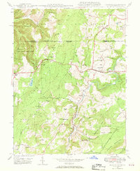
1946 Map of Grantsville
USGS Topo · Published 1969About this map
Savage River State Forest and the upper reaches of the Casselman River dominate this mid-century survey of the Maryland-Pennsylvania border. The rugged topography of Garrett County is marked by high points like Negro Mtn and Meadow Mountain, where remote social infrastructure is anchored by the Negro Mtn Ch and its accompanying Negro Mtn Cem. The National Pike serves as a primary east-west artery, connecting the community of Grantsville to Keysers Ridge. South of the main settlement, the landscape transitions into a more industrial and rural character near Jennings, where the B & O RR and the No 1 Mine reflect the extraction and transport networks of the era. The map provides remarkable genealogical detail, locating family-named schools such as Yoder Sch and landmarks like Zehner Hill and The Dunghill.
Find a feature on this map
68 named features on this map. Tap any name to fly to it.
Don’t see what you’re looking for? This feature index may not catch every label — zoom into the map to look around manually.
Map Details
Editions of this 1946 Grantsville Map
4 editions found
Other maps of this area

1899 · Grantsville
USGS Topo · 1:62,500

1900 · Accident
USGS Topo · 1:62,500

1904 · Grantsville
USGS Topo · 1:62,500

1921 · Meyersdale
USGS Topo · 1:62,500

1922 · Confluence
USGS Topo · 1:62,500

1931 · Confluence
USGS Topo · 1:62,500

1933 · Confluence
USGS Topo · 1:62,500

1939 · Meyersdale
USGS Topo · 1:62,500

1944 · Meyersdale
USGS Topo · 1:62,500

1946 · Grantsville
USGS Topo · 1:24,000