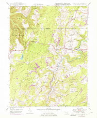
1946 Map of Grantsville
USGS Topo · Published 1976About this map
The Casselman River winds through this Maryland and Pennsylvania borderland, anchoring a landscape of tight-knit mountain settlements and upland farming. Near the town of Grantsville, the historic National Road cuts across the terrain, serving as a primary artery for the region since its early development. The map reveals the social fabric of the 1940s through its dispersed rural infrastructure, including Negro Mtn Ch, Dunghill Ch, and the Voder Sch. Much of the western portion is dominated by the Savage River State Forest, where features like the Lookout Tower near Hi-Point emphasize the rugged elevations of Negro Mtn. To the south, the industrial and residential clusters of Jennings and Bevansville follow the river valley, while family-named landmarks like Ridgley Hill and Shoemaker Hill indicate long-standing local ties to the land.
Find a feature on this map
58 named features on this map. Tap any name to fly to it.
Don’t see what you’re looking for? This feature index may not catch every label — zoom into the map to look around manually.
Map Details
Editions of this 1946 Grantsville Map
4 editions found
Other maps of this area

1899 · Grantsville
USGS Topo · 1:62,500

1900 · Accident
USGS Topo · 1:62,500

1904 · Grantsville
USGS Topo · 1:62,500

1921 · Meyersdale
USGS Topo · 1:62,500

1922 · Confluence
USGS Topo · 1:62,500

1931 · Confluence
USGS Topo · 1:62,500

1933 · Confluence
USGS Topo · 1:62,500

1939 · Meyersdale
USGS Topo · 1:62,500

1944 · Meyersdale
USGS Topo · 1:62,500

1946 · Grantsville
USGS Topo · 1:24,000