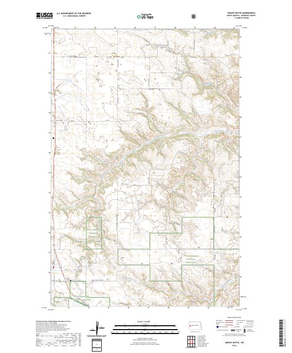
2024 Map of Grassy Butte
USGS Topo · Published 2024About this map
Grassy Butte serves as the primary settlement hub in this McKenzie County landscape, located along the western edge of the expansive Little Missouri National Grassland. The terrain is defined by a dense network of coulees and drainage systems, including Russian Creek in the north and Charlie Bob Creek to the south. These watercourses have carved a complex topography that dictates the placement of rural infrastructure, such as Charlie Bob Creek Rd and Lone Butte Rd.
Find a feature on this map
28 named features on this map. Tap any name to fly to it.
Don’t see what you’re looking for? This feature index may not catch every label — zoom into the map to look around manually.
Map Details
Editions of this 2024 Grassy Butte Map
This is the sole edition of this map. No revisions or reprints were ever made.
Other maps of this area

1953 · Watford City
USGS Topo · 1:250,000

1957 · Watford City
USGS Topo · 1:250,000

1958 · Long X Divide
USGS Topo · 1:24,000

1958 · Lone Butte SE
USGS Topo · 1:24,000

1958 · Lone Butte
USGS Topo · 1:24,000

1967 · Watford City
USGS Topo · 1:250,000

1974 · Grassy Butte SW
USGS Topo · 1:24,000

1974 · Petes Creek
USGS Topo · 1:24,000

1974 · Buckskin Butte
USGS Topo · 1:24,000
1974 · Scairt Woman Draw
USGS Topo · 1:24,000