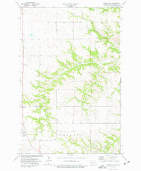
1974 Map of Grassy Butte
USGS Topo · Published 1977About this map
Grassy Butte serves as a prominent landmark in this segment of McKenzie County, where the high plains of western North Dakota are etched by a network of seasonal drainages. In the mid-1970s, the landscape remained predominantly rural and defined by its ranching character, as evidenced by the namesake Ranch Creek and Charlie Bob Creek winding through the terrain. The presence of a Community Cem and a smaller Cem suggests the locations of long-standing local congregations and family plots that anchored this prairie community. Industry is represented by a Scoria Pit near the northern border and a Substation along the southwestern road corridor, indicating the gradual integration of utility infrastructure into the open country. This survey also records the rugged topography around Lone Butte and its tributary, Lone Butte Cr, reflecting the complex erosion patterns typical of the region's badlands borders.
Find a feature on this map
12 named features on this map. Tap any name to fly to it.
Don’t see what you’re looking for? This feature index may not catch every label — zoom into the map to look around manually.
Map Details
Editions of this 1974 Grassy Butte Map
This is the sole edition of this map. No revisions or reprints were ever made.
Other maps of this area

1953 · Watford City
USGS Topo · 1:250,000

1957 · Watford City
USGS Topo · 1:250,000

1958 · Long X Divide
USGS Topo · 1:24,000

1958 · Lone Butte SE
USGS Topo · 1:24,000

1958 · Lone Butte
USGS Topo · 1:24,000

1967 · Watford City
USGS Topo · 1:250,000

1974 · Grassy Butte SW
USGS Topo · 1:24,000

1974 · Petes Creek
USGS Topo · 1:24,000

1974 · Buckskin Butte
USGS Topo · 1:24,000
1974 · Scairt Woman Draw
USGS Topo · 1:24,000