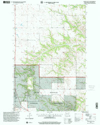
1997 Map of Grassy Butte
USGS Topo · Published 2001About this map
Little Missouri National Grassland dominates this corner of McKenzie County, where the high plains break into the intricate drainages of Russian Creek and Ranch Creek. This 1990s survey preserves a detailed record of local land occupancy, specifically naming homesteads and ranches such as L Chernenko, D Zubke, E Schroeder, and B VanFleet. The small settlement of Grassy Butte serves as the local hub along the corridor of Route 85, supported by the nearby Grassy Butte Substation. Beyond the residential footprints, the map documents the community's infrastructure and industry, from the Community Cem and a smaller unnamed Cem to a Scoria Pit located in the northern reaches. The varied terrain is further defined by seasonal waterways like Lone Butte Creek, Charlie Creek, and Bob Creek, illustrating the remote ranching landscape of western North Dakota.
Find a feature on this map
17 named features on this map. Tap any name to fly to it.
Don’t see what you’re looking for? This feature index may not catch every label — zoom into the map to look around manually.
Map Details
Editions of this 1997 Grassy Butte Map
This is the sole edition of this map. No revisions or reprints were ever made.
Other maps of this area

1953 · Watford City
USGS Topo · 1:250,000

1957 · Watford City
USGS Topo · 1:250,000

1958 · Long X Divide
USGS Topo · 1:24,000

1958 · Lone Butte SE
USGS Topo · 1:24,000

1958 · Lone Butte
USGS Topo · 1:24,000

1967 · Watford City
USGS Topo · 1:250,000

1974 · Grassy Butte SW
USGS Topo · 1:24,000

1974 · Petes Creek
USGS Topo · 1:24,000

1974 · Buckskin Butte
USGS Topo · 1:24,000
1974 · Scairt Woman Draw
USGS Topo · 1:24,000