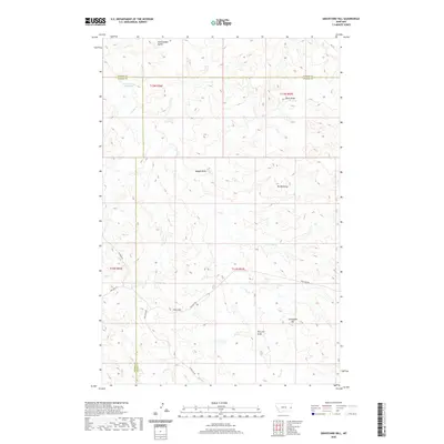
2020 Map of Graveyard Hill
USGS Topo · Published 2020About this map
Graveyard Hill stands as a prominent topographical landmark in this eastern Montana landscape where Prairie, Dawson, and Wibaux counties meet. The terrain is defined by a series of significant drainage systems and high points, including Rattlesnake Butte in the north and the uniquely named Mt McKinley to the east. Water management is central to the area's geography, evidenced by the Little Garrison Reservoir and the Gibson Ditch, which cut through the network of coulees and draws such as Maggie Draw and Kelly Draw. The map reveals a remote ranching or resource-focused environment where transportation is limited to specialized routes like Anticline Rd, Oilfield Rd, and Pine Unit Rd. These roads navigate the complex elevations around Pine Hill and Pine Hill Draw, following the natural contours of Cedar Cr and Ash Cr.
Find a feature on this map
22 named features on this map. Tap any name to fly to it.
Don’t see what you’re looking for? This feature index may not catch every label — zoom into the map to look around manually.
Map Details
Editions of this 2020 Graveyard Hill Map
This is the sole edition of this map. No revisions or reprints were ever made.
Other maps of this area

1953 · Miles City
USGS Topo · 1:250,000

1957 · Miles City
USGS Topo · 1:250,000

1958 · Miles City
USGS Topo · 1:250,000
1967 · Upper Magpie Reservoir
USGS Topo · 1:24,000

1967 · Twin Forks Reservoir
USGS Topo · 1:24,000

1981 · Dorothy Draw
USGS Topo · 1:24,000

1981 · Ayer Spring NE
USGS Topo · 1:24,000

1981 · Rocking Chair Butte
USGS Topo · 1:24,000

1981 · Wibaux
USGS Topo · 1:100,000

1982 · Hodges
USGS Topo · 1:24,000