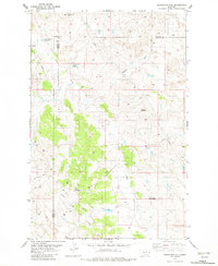
1982 Map of Graveyard Hill
USGS Topo · Published 1982About this map
The South Pine Oil Field dominates the southwestern portion of this landscape, where the confluence of Prairie, Dawson, and Wibaux counties meets in the high plains of eastern Montana. This industrial footprint is characterized by numerous Oil Wells and Drill Holes connected by a network of subterranean pipelines, illustrating the regional energy development of the early 1980s.
Find a feature on this map
19 named features on this map. Tap any name to fly to it.
Don’t see what you’re looking for? This feature index may not catch every label — zoom into the map to look around manually.
Map Details
Editions of this 1982 Graveyard Hill Map
This is the sole edition of this map. No revisions or reprints were ever made.
Other maps of this area

1953 · Miles City
USGS Topo · 1:250,000

1957 · Miles City
USGS Topo · 1:250,000

1958 · Miles City
USGS Topo · 1:250,000
1967 · Upper Magpie Reservoir
USGS Topo · 1:24,000

1967 · Twin Forks Reservoir
USGS Topo · 1:24,000

1981 · Dorothy Draw
USGS Topo · 1:24,000

1981 · Ayer Spring NE
USGS Topo · 1:24,000

1981 · Rocking Chair Butte
USGS Topo · 1:24,000

1981 · Wibaux
USGS Topo · 1:100,000

1982 · Hodges
USGS Topo · 1:24,000