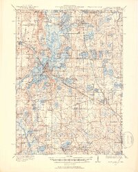
1920 Map of Grays Lake
USGS Topo · Published 1953About this map
The Fox River and its intricate network of glacial lakes dominate this landscape in the years following the Great War. This region, characterized by its labyrinth of water bodies including Pistakee Lake, Lake Marie, and Grass Lake, shows a transition from agricultural prairie to a burgeoning resort and residential district. The presence of numerous small islands like Crabapple Island and Coon Island, alongside peninsulas such as Stanton Pt, highlights the complex shoreline that defined the local geography before mid-century development intensified.
Find a feature on this map
133 named features on this map. Tap any name to fly to it.
Don’t see what you’re looking for? This feature index may not catch every label — zoom into the map to look around manually.
Map Details
Editions of this 1920 Grays Lake Map
3 editions found

Other maps of this area

1892 · Racine
USGS Topo · 1:62,500

1893 · Silver Lake
USGS Topo · 1:62,500

1893 · Geneva
USGS Topo · 1:62,500

1900 · Highwood
USGS Topo · 1:62,500

1904 · Lake Geneva
USGS Topo · 1:62,500

1905 · Racine
USGS Topo · 1:62,500

1906 · Silver Lake
USGS Topo · 1:62,500

1906 · Lake Geneva
USGS Topo · 1:62,500

1906 · Waukegan
USGS Topo · 1:62,500

1908 · Waukegan
USGS Topo · 1:62,500