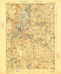
1923 Map of Grays Lake
USGS Topo · Published 1923About this map
Antioch and the surrounding Chain O'Lakes region define the northern landscape of this 1920s survey. The area is dominated by an intricate network of water bodies, including Pistakee Lake, Nippersink Lake, and Lake Marie, which facilitated the development of early resort communities like Fox Lake and Ingleside. The transportation infrastructure of the era is anchored by the Chicago Milwaukee and St Paul RR and the Minneapolis St Paul and Sault Ste Marie RR, which provided vital connections for both residents and visitors.
Find a feature on this map
134 named features on this map. Tap any name to fly to it.
Don’t see what you’re looking for? This feature index may not catch every label — zoom into the map to look around manually.
Map Details
Editions of this 1923 Grays Lake Map
4 editions found

Other maps of this area

1892 · Racine
USGS Topo · 1:62,500

1893 · Silver Lake
USGS Topo · 1:62,500

1893 · Geneva
USGS Topo · 1:62,500

1900 · Highwood
USGS Topo · 1:62,500

1904 · Lake Geneva
USGS Topo · 1:62,500

1905 · Racine
USGS Topo · 1:62,500

1906 · Silver Lake
USGS Topo · 1:62,500

1906 · Lake Geneva
USGS Topo · 1:62,500

1906 · Waukegan
USGS Topo · 1:62,500

1908 · Waukegan
USGS Topo · 1:62,500