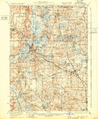
1923 Map of Grays Lake
USGS Topo · Published 1932About this map
The glacial lakelands of northeastern Illinois are documented here during the early twentieth century, showing a region defined by its complex hydrology and growing rail connectivity. The Chicago Milwaukee and St Paul and the Minneapolis St Paul and Sault Ste Marie railroads intersect the landscape, facilitating the development of lakeside communities like Antioch, Fox Lake, and Lake Villa. These transport lines linked the chain of lakes—including Lake Marie, Grass Lake, and Pistakee Lake—to broader regional markets, while many rural areas remained dominated by family-named schools such as Johnson School and Big Hollow School. The map reveals the intricate shoreline of Columbia Bay and Nippersink Lake, where seasonal recreation began to influence the local economy. Religious and civic foundations are anchored by St Marys Chapel and early burial grounds like Union Cemetery and Fort Hill Cemetery.
Find a feature on this map
119 named features on this map. Tap any name to fly to it.
Don’t see what you’re looking for? This feature index may not catch every label — zoom into the map to look around manually.
Map Details
Editions of this 1923 Grays Lake Map
4 editions found

Other maps of this area

1892 · Racine
USGS Topo · 1:62,500

1893 · Silver Lake
USGS Topo · 1:62,500

1893 · Geneva
USGS Topo · 1:62,500

1900 · Highwood
USGS Topo · 1:62,500

1904 · Lake Geneva
USGS Topo · 1:62,500

1905 · Racine
USGS Topo · 1:62,500

1906 · Silver Lake
USGS Topo · 1:62,500

1906 · Lake Geneva
USGS Topo · 1:62,500

1906 · Waukegan
USGS Topo · 1:62,500

1908 · Waukegan
USGS Topo · 1:62,500