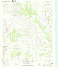
1960 Map of Grays Prairie
USGS Topo · Published 1979About this map
Grays Prairie and the surrounding Kaufman County landscape are defined by a network of winding waterways, including Big Cottonwood Creek, Kings Creek, and Bois d'Arc Creek. This 1960s perspective shows the area prior to significant modern development, anchored by small rural centers such as Lively, Stubbs, and Coney. Local history is centered around landmarks like the Grays Prairie Cem and Shady Grove Ch, which served as the social and spiritual hubs for the dispersed farming community. The Southern Pacific tracks cut across the northeastern corner of the sheet, providing a vital rail link through this prairie terrain. The map also delineates the extensive boundaries of the Tarrant County Water Control and Improvement District No. 1, illustrating the region's managed approach to water resources and agriculture during the mid-twentieth century.
Find a feature on this map
12 named features on this map. Tap any name to fly to it.
Don’t see what you’re looking for? This feature index may not catch every label — zoom into the map to look around manually.
Map Details
Editions of this 1960 Grays Prairie Map
Other maps of this area

1920 · Kemp
USGS Topo · 1:62,500

1954 · Dallas
USGS Topo · 1:250,000

1956 · Kaufman
USGS Topo · 1:62,500

1957 · Kemp
USGS Topo · 1:62,500

1958 · Dallas
USGS Topo · 1:250,000

1960 · Tool
USGS Topo · 1:24,000

1960 · Grays Prairie
USGS Topo · 1:24,000

1961 · Kemp
USGS Topo · 1:24,000

1962 · Rosser SW
USGS Topo · 1:24,000
1962 · Styx
USGS Topo · 1:24,000