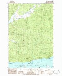
1985 Map of Grays River
USGS Topo · Published 1986About this map
Grays River Valley serves as the focal point of this coastal Washington survey, where the winding river meets the north bank of the Columbia River. The map documents a rural landscape defined by logging and maritime activity, noting the presence of a Covered Bridge and the Grays River Cem. Settlement patterns are concentrated along the riverfronts at Brookfield and Dahlia, while much of the southern shoreline is preserved within the Lewis and Clark National Wildlife Refuge. The terrain transitions from the tidewater islands like Woody Island and Grassy Island to the steep slopes of Elk Mountain and Egmon Mountain. Local family and geographic history is embedded in labels for Jim Crow Hill and Pillar Rock, reflecting a time when river navigation and valley farming were the primary drivers of the local economy.
Find a feature on this map
53 named features on this map. Tap any name to fly to it.
Don’t see what you’re looking for? This feature index may not catch every label — zoom into the map to look around manually.
Map Details
Editions of this 1985 Grays River Map
This is the sole edition of this map. No revisions or reprints were ever made.
Other maps of this area

1940 · Svensen
USGS Topo · 1:62,500

1940 · Brookfield
USGS Topo · 1:62,500

1941 · Skamokawa
USGS Topo · 1:62,500

1941 · Cathlamet
USGS Topo · 1:62,500

1949 · Upper Naselle River
USGS Topo · 1:24,000

1949 · Cathlamet Bay
USGS Topo · 1:24,000

1949 · Rosburg
USGS Topo · 1:24,000

1953 · Hoquiam
USGS Topo · 1:250,000

1953 · Skamokawa
USGS Topo · 1:62,500

1953 · Cathlamet
USGS Topo · 1:62,500