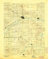
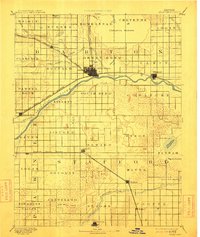
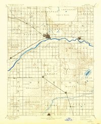
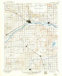
1893 Map of Great Bend
USGS Topo · Published 1906About this map
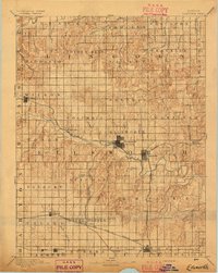
Arkansas River curves sharply through this late nineteenth-century landscape, anchoring the settlement of Great Bend at its northernmost arc. The region is defined by the early expansion of two major rail lines: the Atchison Topeka and Santa Fe Railroad and the Missouri Pacific Railway, which facilitated the growth of frontier towns like Ellinwood and Pawnee Rock. To the north, the distinctive basin of Cheyenne Bottoms dominates the terrain, while the southern portion of the sheet reveals a more porous environment characterized by Salt Marsh, Salt Springs, and Little Salt Marsh near the town of Hudson. These features highlight the transition from the fertile river valley to the more arid, alkaline basins of central Kansas. Small communities such as Seward, Heizer, and Bedford are recorded here in their early stages of development, often established as strategic stops along the expanding rail networks.
Find a feature on this map
54 named features on this map. Tap any name to fly to it.
Don’t see what you’re looking for? This feature index may not catch every label — zoom into the map to look around manually.
Map Details
Editions of this 1893 Great Bend Map
5 editions found
Other maps of this area

1889 · Larned
USGS Topo · 1:125,000

1889 · Kinsley
USGS Topo · 1:125,000

1891 · Great Bend
USGS Topo · 1:125,000

1891 · Larned
USGS Topo · 1:125,000

1892 · Kinsley
USGS Topo · 1:125,000

1892 · Kingman
USGS Topo · 1:125,000

1892 · Pratt
USGS Topo · 1:125,000

1893 · Great Bend
USGS Topo · 1:125,000
1894 · Ellsworth
USGS Topo · 1:125,000

1894 · Kinsley
USGS Topo · 1:125,000