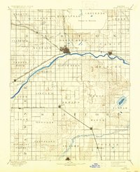
1893 Map of Great Bend
USGS Topo · Published 1937About this map
The Arkansas River carves a massive arc through this Central Kansas landscape, anchoring the settlement of Great Bend and providing a natural corridor for the Atchison Topeka and Santa Fe Railroad. To the north, the expansive wetland basin of Cheyenne Bottoms stands in sharp contrast to the organized agricultural grid of townships like Eureka and Homestead. In the southeast, a unique cluster of saline features including Salt Marsh, Little Salt Marsh, and Salt Springs highlights the region's diverse hydrology.
Find a feature on this map
50 named features on this map. Tap any name to fly to it.
Don’t see what you’re looking for? This feature index may not catch every label — zoom into the map to look around manually.
Map Details
Editions of this 1893 Great Bend Map
5 editions found
Other maps of this area

1889 · Larned
USGS Topo · 1:125,000

1889 · Kinsley
USGS Topo · 1:125,000

1891 · Great Bend
USGS Topo · 1:125,000

1891 · Larned
USGS Topo · 1:125,000

1892 · Kinsley
USGS Topo · 1:125,000

1892 · Kingman
USGS Topo · 1:125,000

1892 · Pratt
USGS Topo · 1:125,000

1893 · Great Bend
USGS Topo · 1:125,000

1894 · Ellsworth
USGS Topo · 1:125,000

1894 · Kinsley
USGS Topo · 1:125,000