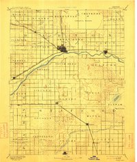
1893 Map of Great Bend
USGS Topo · Published 1913About this map
The Arkansas River carves a sweeping arc across this Central Kansas landscape, defining the early geography of Barton and Stafford counties. Surveyed in 1889, the map reveals a region transitioning into a productive agricultural and rail hub. The Atchison Topeka and Santa Fe Railroad parallels the river, connecting established grain and cattle centers like Great Bend, Ellinwood, and Pawnee Rock. To the north, the distinctive natural basin of Cheyenne Bottoms stands in contrast to the orderly township grids. Further south, the Missouri Pacific Railway serves a string of smaller settlements including Seward, Ratt, and Hudson. The presence of several alkaline features, such as Salt Marsh and Salt Springs, highlights the unique hydrology of the area, while smaller watercourses like Walnut Creek and Rattlesnake Creek provide the essential drainage for the surrounding farmsteads and townships.
Find a feature on this map
55 named features on this map. Tap any name to fly to it.
Don’t see what you’re looking for? This feature index may not catch every label — zoom into the map to look around manually.
Map Details
Editions of this 1893 Great Bend Map
5 editions found
Other maps of this area

1889 · Larned
USGS Topo · 1:125,000

1889 · Kinsley
USGS Topo · 1:125,000

1891 · Great Bend
USGS Topo · 1:125,000

1891 · Larned
USGS Topo · 1:125,000

1892 · Kinsley
USGS Topo · 1:125,000

1892 · Kingman
USGS Topo · 1:125,000

1892 · Pratt
USGS Topo · 1:125,000

1893 · Great Bend
USGS Topo · 1:125,000

1894 · Ellsworth
USGS Topo · 1:125,000

1894 · Kinsley
USGS Topo · 1:125,000