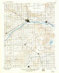
1893 Map of Great Bend
USGS Topo · Published 1949About this map
Great Bend serves as the central hub of this late-19th-century landscape, positioned where the Atchison Topeka and Santa Fe Railroad meets the north bank of the Arkansas River. The map reveals a transition between the established riverfront communities like Ellinwood and Pawnee Rock and the marshy expanses of the east and north. To the northeast, the massive Cheyenne Bottoms creates a distinct break in the township grid, while the southeastern corner is dominated by the Salt Marsh, Salt Springs, and Little Salt Marsh.
Find a feature on this map
52 named features on this map. Tap any name to fly to it.
Don’t see what you’re looking for? This feature index may not catch every label — zoom into the map to look around manually.
Map Details
Editions of this 1893 Great Bend Map
5 editions found
Other maps of this area

1889 · Larned
USGS Topo · 1:125,000

1889 · Kinsley
USGS Topo · 1:125,000

1891 · Great Bend
USGS Topo · 1:125,000

1891 · Larned
USGS Topo · 1:125,000

1892 · Kinsley
USGS Topo · 1:125,000

1892 · Kingman
USGS Topo · 1:125,000

1892 · Pratt
USGS Topo · 1:125,000

1893 · Great Bend
USGS Topo · 1:125,000

1894 · Ellsworth
USGS Topo · 1:125,000

1894 · Kinsley
USGS Topo · 1:125,000