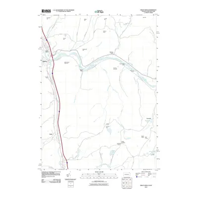
2010 Map of Great Bend
USGS Topo · Published 2010About this map
The Susquehanna River carves a dramatic oxbow through this borderland region, defining the settlements of Great Bend and Hallstead. The landscape is characterized by a series of prominent elevations such as Maunatome Mountain and Smokey Mountain, which overlook the river valley and its associated transportation corridors. Long-established travel routes, including the Old Lackawanna Trl, follow the natural contours of the river and Salt Lick Creek, while smaller communities like Hickory Grove and Brushville occupy the higher ground to the east. The presence of Highland Cemetery and Maple Ridge Cemetery provides significant points of interest for genealogists, while the Susquehanna Boy Scout Camp near Lewis Corners highlights the area's recreational use. Notable water bodies such as Brushville Lake and East Lake further define the local geography, alongside several smaller streams including Little Egypt Creek and Deacon Brook.
Find a feature on this map
63 named features on this map. Tap any name to fly to it.
Don’t see what you’re looking for? This feature index may not catch every label — zoom into the map to look around manually.
Map Details
Editions of this 2010 Great Bend Map
This is the sole edition of this map. No revisions or reprints were ever made.
Other maps of this area

1904 · Binghamton
USGS Topo · 1:62,500

1905 · Nineveh
USGS Topo · 1:62,500

1932 · Susquehanna
USGS Topo · 1:62,500

1935 · Susquehanna
USGS Topo · 1:62,500

1937 · Binghamton East
USGS Topo · 1:24,000

1942 · Binghamton East
USGS Topo · 1:31,680

1943 · Montrose
USGS Topo · 1:62,500

1945 · Montrose
USGS Topo · 1:62,500

1948 · Binghamton
USGS Topo · 1:250,000

1950 · Binghamton
USGS Topo · 1:250,000