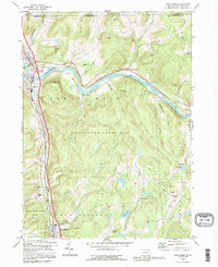
1992 Map of Great Bend
USGS Topo · Published 1995About this map
The Susquehanna River carves a dramatic oxbow through the northern reaches of this map, defining the historic twin settlements of Great Bend and Hallstead. This 1992 survey documents a landscape where traditional valley agriculture and upland wilderness coexist, notably within the sprawling State Game Lands No 35. The presence of the Conrail line and Interstate 81 highlights the corridor's enduring role as a vital transportation artery between the Southern Tier of New York and the coal regions of Pennsylvania.
Find a feature on this map
49 named features on this map. Tap any name to fly to it.
Don’t see what you’re looking for? This feature index may not catch every label — zoom into the map to look around manually.
Map Details
Editions of this 1992 Great Bend Map
This is the sole edition of this map. No revisions or reprints were ever made.
Other maps of this area

1904 · Binghamton
USGS Topo · 1:62,500

1905 · Nineveh
USGS Topo · 1:62,500

1932 · Susquehanna
USGS Topo · 1:62,500

1935 · Susquehanna
USGS Topo · 1:62,500

1937 · Binghamton East
USGS Topo · 1:24,000

1942 · Binghamton East
USGS Topo · 1:31,680

1943 · Montrose
USGS Topo · 1:62,500

1945 · Montrose
USGS Topo · 1:62,500

1948 · Binghamton
USGS Topo · 1:250,000

1950 · Binghamton
USGS Topo · 1:250,000