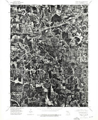
1974 Map of Green City NE
USGS Topo · Published 1976About this map
Hartford and Glayville anchor this 1974 orthophotographic study of Putnam County, Missouri. Unlike traditional topographic maps, this imagery provides a direct overhead view of the mid-1970s agricultural landscape, where the irregular patterns of woodlots and drainage ravines contrast sharply with the rigid geometry of tilled fields. The settlement at Hartford appears as a distinct cluster of structures at a rural crossroads, while the surrounding acreage shows the complex drainage patterns that define this section of the northern Missouri plains. This aerial perspective is particularly valuable for identifying former field boundaries, farmstead locations, and the original timber stands that persisted amidst decades of intensive cultivation.
Find a feature on this map
2 named features on this map. Tap any name to fly to it.
Don’t see what you’re looking for? This feature index may not catch every label — zoom into the map to look around manually.
Map Details
Editions of this 1974 Green City NE Map
This is the sole edition of this map. No revisions or reprints were ever made.
Other maps of this area

1911 · Queen City
USGS Topo · 1:62,500

1912 · Green City
USGS Topo · 1:62,500

1913 · Queen City
USGS Topo · 1:62,500

1914 · Green City
USGS Topo · 1:62,500

1939 · Centerville
USGS Topo · 1:62,500

1941 · Centerville
USGS Topo · 1:62,500

1954 · Centerville
USGS Topo · 1:250,000

1957 · Centerville
USGS Topo · 1:250,000

1958 · Centerville
USGS Topo · 1:250,000
1974 · Green City NW
USGS Topo · 1:24,000