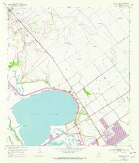
1952 Map of Green Lake
USGS Topo · Published 1976About this map
Green Lake and its surrounding coastal wetlands dominate this mid-century landscape in Calhoun County. The terrain is defined by a complex network of waterways, including Black Bayou, Jones Bayou, and Goff Bayou, which thread through the lowlands protected by an extensive series of levees. The intersection of heavy industry and transportation is evident in the northwestern Oil Field, where a pipeline and numerous oil wells mark the extraction economy of the Texas Gulf Coast.
Find a feature on this map
20 named features on this map. Tap any name to fly to it.
Don’t see what you’re looking for? This feature index may not catch every label — zoom into the map to look around manually.
Map Details
Editions of this 1952 Green Lake Map
2 editions found
Other maps of this area

1951 · Bloomington
USGS Topo · 1:24,000

1952 · Tivoli
USGS Topo · 1:24,000

1952 · Bloomington SW
USGS Topo · 1:24,000

1952 · Kamey
USGS Topo · 1:24,000

1952 · Austwell
USGS Topo · 1:24,000

1952 · Seadrift
USGS Topo · 1:24,000

1952 · Port Lavaca West
USGS Topo · 1:24,000

1952 · Placedo
USGS Topo · 1:24,000

1952 · Green Lake
USGS Topo · 1:24,000

1953 · Beeville
USGS Topo · 1:250,000