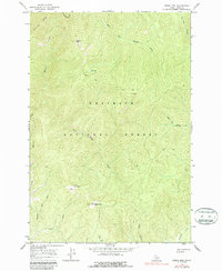
1966 Map of Green Mountain
USGS Topo · Published 1987About this map
Green Mtn and Granite Peak dominate this mid-century survey of high-elevation interior Idaho, showing a landscape defined by forest management and rugged utility within the Nezperce National Forest. The map documents a period when lookouts and foot travel remained vital to backcountry operations, evidenced by the Lookout Tower atop the main summit and a network of both a Jeep Trail and a Pack Trail winding through the drainage basins. Water systems are highly detailed, with the East Fork Meadow Creek and Bargamin Creek carving deep valleys between ridges like Matteson Ridge. Small-scale human activity is sparse but notable, including a solitary Cabin in the southwest and scattered Prospects near the center, indicating the enduring interest in local mineral potential. This 1960s snapshot captures the wilderness character of the region before modern infrastructural shifts.
Find a feature on this map
22 named features on this map. Tap any name to fly to it.
Don’t see what you’re looking for? This feature index may not catch every label — zoom into the map to look around manually.
Map Details
Editions of this 1966 Green Mountain Map
2 editions found
Other maps of this area

1956 · Elk City
USGS Topo · 1:250,000

1960 · Elk City
USGS Topo · 1:250,000

1966 · Green Mtn.
USGS Topo · 1:24,000

1966 · Three Prong Mountain
USGS Topo · 1:24,000
1966 · Wylies Peak
USGS Topo · 1:24,000

1966 · Sable Hill
USGS Topo · 1:24,000
1966 · Running Lake
USGS Topo · 1:24,000
1966 · Vermilion Peak
USGS Topo · 1:24,000

1977 · Boston Mtn
USGS Topo · 1:24,000

1978 · Spread Creek Point
USGS Topo · 1:24,000