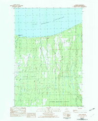
1982 Map of Green
USGS Topo · Published 1983About this map
The settlement of Green sits along the southern shore of Lake Superior in the early 1980s, marking a transition point between the rugged coastal landscape and the industrial interior of Ontonagon County. Evidence of the region’s extractive history is visible in the Old RR Grade and the large Tailings Pond near Caribou Cr. The map details a dense network of waterways including the Cranberry River, Halfway River, and Potato River that flow north toward the lake from the heights of the Ottawa National Forest. Local civic life is anchored by a Townhall and a small Cem located near the shoreline road, while the western edge of the sheet touches the boundary of Porcupine Mountains State Park. This survey captures the rural character of Carp Lake and Ontonagon townships just as modern utility infrastructure, indicated by a prominent Pipeline, began to cross the timbered terrain.
Find a feature on this map
33 named features on this map. Tap any name to fly to it.
Don’t see what you’re looking for? This feature index may not catch every label — zoom into the map to look around manually.
Map Details
Editions of this 1982 Green Map
This is the sole edition of this map. No revisions or reprints were ever made.
Other maps of this area

1949 · Matchwood NW
USGS Topo · 1:24,000

1949 · White Pine
USGS Topo · 1:24,000

1949 · Bergland NE
USGS Topo · 1:24,000

1955 · Ontonagon
USGS Topo · 1:62,500

1956 · Bergland NE
USGS Topo · 1:24,000

1956 · Bergland
USGS Topo · 1:62,500

1956 · White Pine
USGS Topo · 1:24,000

1956 · Matchwood NW
USGS Topo · 1:24,000

1956 · White Pine
USGS Topo · 1:62,500

1956 · Matchwood
USGS Topo · 1:62,500