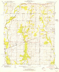
1938 Map of Greenbrier
USGS Topo · Published 1956About this map
The Southern Railway corridor anchors this 1938 landscape, connecting the rural communities of Greenbrier and Belle Mina across the Tennessee Valley. The area is defined by its agrarian character and the recent transformation of the southern shoreline following the creation of the Wheeler Reservation Boundary. Inland, the map reveals a network of small, localized settlements such as Oakland, Burgreen Corner, and Manley Crossroad, each served by community landmarks like Waldo Chapel and Mt Pleasant Sch. The presence of Wheeler Lake at the southern edge marks a significant shift in the local hydrology, as the reservoir began to influence the drainage of Limestone Creek and Bradford Creek. Genealogists and local historians can find a wealth of specific family-named sites, from Betz Spring to Moseys Chapel, reflecting the deeply rooted social structure of the county line between Limestone and Madison during the pre-war era.
Find a feature on this map
33 named features on this map. Tap any name to fly to it.
Don’t see what you’re looking for? This feature index may not catch every label — zoom into the map to look around manually.
Map Details
Editions of this 1938 Greenbrier Map
3 editions found
Other maps of this area

1888 · Huntsville
USGS Topo · 1:125,000

1892 · Huntsville
USGS Topo · 1:125,000

1935 · Athens
USGS Topo · 1:24,000

1936 · Jeff
USGS Topo · 1:24,000

1936 · Capshaw
USGS Topo · 1:24,000

1936 · Triana
USGS Topo · 1:24,000

1936 · Madison
USGS Topo · 1:24,000

1936 · Decatur
USGS Topo · 1:24,000

1936 · Mason Ridge
USGS Topo · 1:24,000

1936 · Tanner
USGS Topo · 1:24,000